In previous posts "Security quotes : a FSB (successor to the KGB) analyst on Google Earth", "Suri Pluma - a satellite image processing tool and visualizer", "The "threat" by Google Earth has just vanished in the air" I talked about various issues related to satellite imagery and security.
Moreover, I'm also actively covering various emerging Space Warfare issues, and with the recent speculation that the Okno ELINT complex in Tajikistan is becoming Russian and different "schools of thought", there's a lot to come for sure. Google Maps/Earth did not only restart the real estate industry, it made the world a smaller place, a more competitive one, and hopefully a safer one if security counts here.
As of today, I decided to start posting a weekly section, the "Travel Without Moving" series, presenting interesting and publicly obtained imagery of sights that somehow made me an impression. The other day I came across to a (perhaps scraped by now) Typhoon Class Submarines at GoogleSightseeing.com -- the largest and quietest types of submarines.
That's perhaps the perfect moment to mention the cool pictures of a Soviet Underground Submarine Base in the Nuclear Submarine Base that "Until the collapse of the Soviet Union in 1991 Balaklava was one of the most secret towns in Russia. 10km south eas of Sevastopol on the Black Sea Coast, this small town was the home to a Nuclear Submarine Base." Take a tour for yourself!
Showing posts with label Google Earth. Show all posts
Showing posts with label Google Earth. Show all posts
Thursday, May 04, 2006
Travel Without Moving - Typhoon Class Submarines
 Independent Security Consultancy, Threat Intelligence Analysis (OSINT/Cyber Counter Intelligence) and Competitive Intelligence research on demand. Insightful, unbiased, and client-tailored assessments, neatly communicated in the form of interactive reports - because anticipating the emerging threatscape is what shapes the big picture at the end of the day. Approach me at dancho.danchev@hush.com
Wednesday, April 05, 2006
The "threat" by Google Earth has just vanished in the air
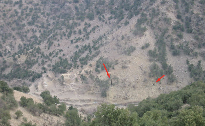
Or has it actually? In one of my previous posts "Security quotes : a FSB (successor to the KGB) analyst on Google Earth" I mentioned the usefulness of Google Earth by the general public, and the possibility to assist terrorists. The most popular argument on how useless the publicly available satellite imagery is that it doesn't provide a high-resolution images, and recent data as well -- that's of course unless you don't request one, but isn't it bothering you that here we have a street-side drive-by POC?
The recently introduced Windows Live Local Street-Side Drive-by (A9's maps have been around for quite a while), is setting a new benchmark for interactive OSINT -- if any as this is also a privacy violation that can be compared with efforts like these if it was in real-time. Having had several conversations with a friend that's way too much into satellite imagery than me, I've realized that starting from the basic fact of targeting a well known or a movie-plot location doesn't really requires satellite imagery. I find that today's sources basically provoke the imagination and the self-confidence -- and hopefully nothing more!
There have been numerous articles on the threat posed by Google Earth, and India seems to be the most concerned country about this for the time being :
"Chief of the Indian Army General J.J. Singh warns that Google Earth could endanger national security by providing high resolution photographs of strategic defense facilities. The software could prove especially useful to countries that do not have their own satellite capabilities. Singh called Google Earth a shared concern for all countries, requiring all countries to cooperate to address the issue. Indian President APJ Abdul Kalam has also expressed concerns over Google Earth and national security."
You can spend hours counting the cars in front of NSA's parking lot through public satellite imagery resources, still you would never get to see what's going on in there, I guess things have greatly changed since the days when tourists sent over the USSR, or exactly the opposite, to the U.S, would try to get hold of as many maps as possible finish the puzzle.
In some of my previous posts on Cyberterrorism, I said that terrorists are not rocket scientists until we make them feel so, and I'm still sticking to this statement, what about you? As a matter of fact, Schneier is inviting everyone to participate in the Movie-Plot Threat contest -- stuff like terrorist EMP warfare, Nuclear truck bombs (the same story from 3 years ago), and other science fiction scenarios worth keeping an eye on.
Terrorism is a profitable paranoia these days, that's constantly fuelling further growth in defense and intelligence spending, as satellite imagery is promoted for the bust of Bin Laden, whereas their infrastructure seems to pretty safe, isn't it? (More photos, 1, 2, 3, 4, 5, 6) I'd rather we have known parties as an adversary, the way it used to be during the Cold War, whose competition sent us in Space, and landed us on the Moon , instead of seeing terrorists everywhere and missing the big opportunity.
Technorati tags:
Security, Terrorism, Cyberterrorism, Privacy, Google Earth, Google Maps, Space, Microsoft Live, New Media
Independent Security Consultancy, Threat Intelligence Analysis (OSINT/Cyber Counter Intelligence) and Competitive Intelligence research on demand. Insightful, unbiased, and client-tailored assessments, neatly communicated in the form of interactive reports - because anticipating the emerging threatscape is what shapes the big picture at the end of the day. Approach me at dancho.danchev@hush.com
Wednesday, January 04, 2006
Security quotes : a FSB (successor to the KGB) analyst on Google Earth
 "Lt.
Gen. Leonid Sazhin, an analyst for the Federal Security Service, the
Russian security agency that succeeded the K.G.B., was quoted by
Itar-Tass as saying: "Terrorists don't need to reconnoiter their target.
Now an American company is working for them." A great quote,
and I find it totally true. The point is, not to look for
high-resolution imagery, but to harness the power of OSINT, improve
their confidence by observing the targets "from the sky", and actually
plan and coordinate its activities on huge territories. AJAX anyone? :)
"Lt.
Gen. Leonid Sazhin, an analyst for the Federal Security Service, the
Russian security agency that succeeded the K.G.B., was quoted by
Itar-Tass as saying: "Terrorists don't need to reconnoiter their target.
Now an American company is working for them." A great quote,
and I find it totally true. The point is, not to look for
high-resolution imagery, but to harness the power of OSINT, improve
their confidence by observing the targets "from the sky", and actually
plan and coordinate its activities on huge territories. AJAX anyone? :)However, the public has always been good at bringing the real issue to the rest of the world. There have been numerous attempts to spot sensitive locations, and I wouldn't be myself if I don't share the joys of the Eyeball Series with you. Of course, in case you haven't come across the initiative earlier. However, the way it gives terrorists or enemies these opportunities, it also serves the general public by acting as an evidence for the existence of espionage sentiments, here and there. Echelon's Yakima Research Station was spotted on GoogleMaps, originally by Cryptome, see the dishes there? Any thoughts in here? Can Microsft's Local Live with its highly differentiated bird eye view on important locations turn into a bigger risk the the popularity of Google's services?
Technorati tags :
Google Earth,Google Maps,satellite imagery,OSINT,security,terrorism
Independent Security Consultancy, Threat Intelligence Analysis (OSINT/Cyber Counter Intelligence) and Competitive Intelligence research on demand. Insightful, unbiased, and client-tailored assessments, neatly communicated in the form of interactive reports - because anticipating the emerging threatscape is what shapes the big picture at the end of the day. Approach me at dancho.danchev@hush.com
Security quotes : a FSB (successor to the KGB) analyst on Google Earth
"Lt. Gen. Leonid Sazhin, an analyst for the Federal Security Service, the Russian security agency that succeeded the K.G.B., was quoted by Itar-Tass as saying: "Terrorists don't need to reconnoiter their target. Now an American company is working for them." A great quote, and I find it totally true. The point is, not to look for high-resolution imagery, but to harness the power of OSINT, improve their confidence by observing the targets "from the sky", and actually plan and coordinate its activities on huge territories. AJAX anyone? :)
However, the public has always been good at bringing the real issue to the rest of the world. There have been numerous attempts to spot sensitive locations, and I wouldn't be myself if I don't share the joys of the Eyeball Series with you. Of course, in case you haven't come across the initiative earlier.
However, the way it gives terrorists or enemies these opportunities, it also serves the general public by acting as an evidence for the existence of espionage sentiments, here and there. Echelon's Yakima Research Station was spotted on GoogleMaps, originally by Cryptome, see the dishes there? Any thoughts in here? Can Microsft's Local Live with its highly differentiated bird eye view on important locations turn into a bigger risk the the popularity of Google's services?
Technorati tags :
Google Earth,Google Maps,satellite imagery,OSINT,security,terrorism
Independent Security Consultancy, Threat Intelligence Analysis (OSINT/Cyber Counter Intelligence) and Competitive Intelligence research on demand. Insightful, unbiased, and client-tailored assessments, neatly communicated in the form of interactive reports - because anticipating the emerging threatscape is what shapes the big picture at the end of the day. Approach me at dancho.danchev@hush.com
Subscribe to:
Posts (Atom)